Today in class we learned How Geographers Describe Where Things Are? Define map scale, projection, meridian, longitude, parallel, latitude, prime meridian,
we tried Understanding and describing the role of map scale and map projection in reading maps
and we Identify the three main map projections
Towards the middle of class we disscused that, "the map" is an essential tool and component of geography. The map is defined as a graphic representation of a portion of Earth that is usually drawn to scale on a flat surface. It is the central way geographers organize and analyze information. Maps are also a powerful means of displaying and communicating geographic information. To better understand what the map is showing us, we must first understand the components of the map itself Level of detail and the amount of area covered on the map depend on its map scale.
we also went over map scales and talked about Relationship of a feature’s size on a map to its actual size on Earth
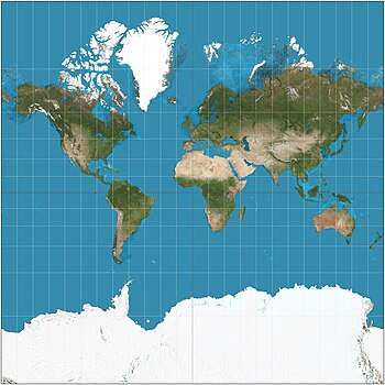
Towards the end of class of class we disscued the the Scientific method of transferring locations on Earth’s surface to a flat map is called projection.
we talked about how a map A map projection is a systematic transformation of the latitudes and longitudes of locations from the surface of a sphere (3D) into locations on a plane (2D). Maps cannot be created without map projections. All map projections necessarily distort the surface in some fashion.
–Four types of distortion
1.Shape of an area can be distorted.
2.Distance between points may become increased or decreased.
3.Relative size of different areas can be altered.
4.Direction between points can be distorted.
Comments
Post a Comment